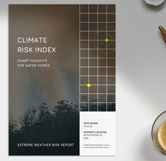
Extreme Weather Risk Report
Our report utilises advanced climate models to assess your property's exposure to extreme weather risk - both now and in the future. Includes:
- Fire, Flood, Cyclone, Storm & Earthquake Risk
- Current & Future 2050 Risk Score
- Risk Score Breakdown By Each Weather Event
- Comprehensive 20+ Page Analysis
Extreme Weather Risk Report

Extreme Weather Risk
Australia faces a growing threat from extreme weather events. Insurance is becoming unaffordable, or unavailable entirely, for an increasing number of homeowners. The Climate Council warns 1 in 23 properties is already at high risk, and over 1.3 million homes could become uninsurable within 75 years.
Our report translates complex risk data into clear insights, providing you with an overall risk score and a detailed explanation of the key risk factors that could affect your property.
We use the same types of data sources relied on by insurers to assess your property’s risk, along with advanced, industry-leading climate models to forecast future threats.
Current Risk
To assess your property’s current risk exposure, we draw on data from over 50 trusted data sources and our own private databases.
Our analysis includes examining historic events near your property, including past bushfire, storm, and flood events. We review long-term weather trends, such as extreme rainfall and forest fire danger indexes.
We also analyse your property’s unique physical characteristics and surroundings. Factors such as elevation, slope, vegetation type, and proximity to water all influence your level of risk.
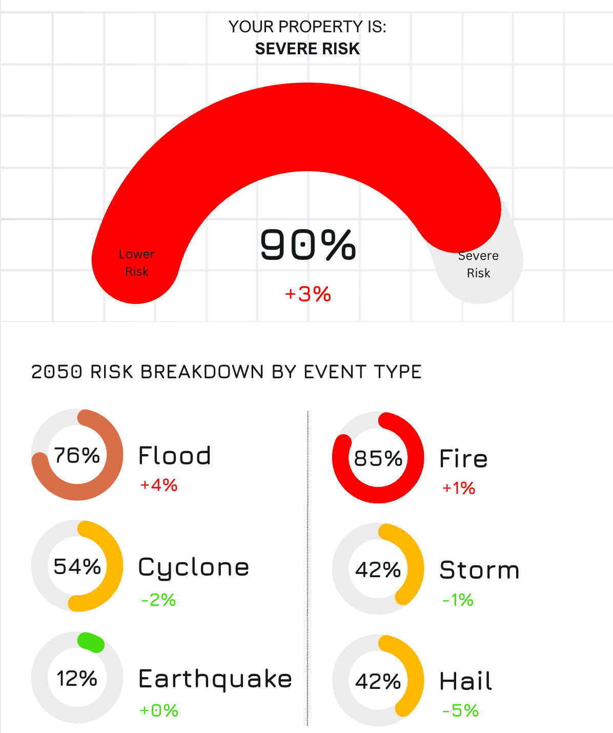
2050 Risk
With a changing climate, your property’s risk will likely change too. That’s why our report also analyses your property’s future risk by identifying trends and modelling how hazards like bushfires, floods, cyclones, storms, and earthquakes may evolve.
To assess future risk, we build on our analysis of your property’s current risk and integrate projections from an ensemble of advanced climate models.
The result is a future-focused risk score for your property in 2050, along with clear explanations of the factors contributing to any increase or decrease in your risk profile.
If you have any questions, you are always welcome to contact us. We'll get back to you as soon as possible, within 24 hours on weekdays.
-
Shipping Information
Use this text to answer questions in as much detail as possible for your customers.
-
Customer Support
Use this text to answer questions in as much detail as possible for your customers.
-
FAQ’s
Use this text to answer questions in as much detail as possible for your customers.
-
Contact Us
Use this text to answer questions in as much detail as possible for your customers.
What Extreme Weather Events Are Analysed?
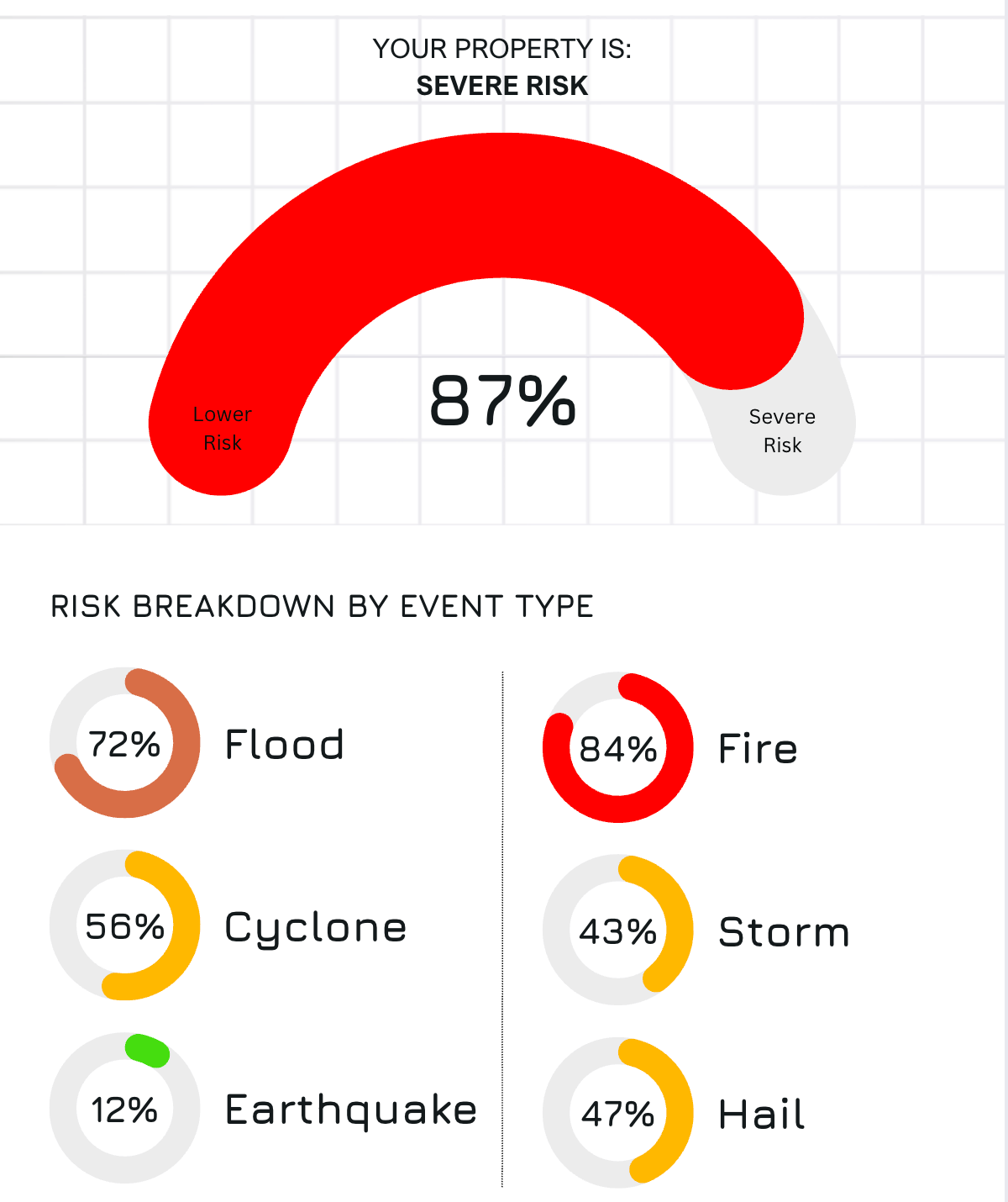
Our Extreme Weather Risk Report focuses on six major natural hazards: bushfires, floods, cyclones, storms, hail and earthquakes.
These are the events that pose the greatest threat to properties across Australia and are the primary risks assessed by insurance companies when determining whether to provide cover, and at what cost.
By concentrating on these hazards, we ensure that our analysis aligns with the same criteria insurers use to evaluate property risk.
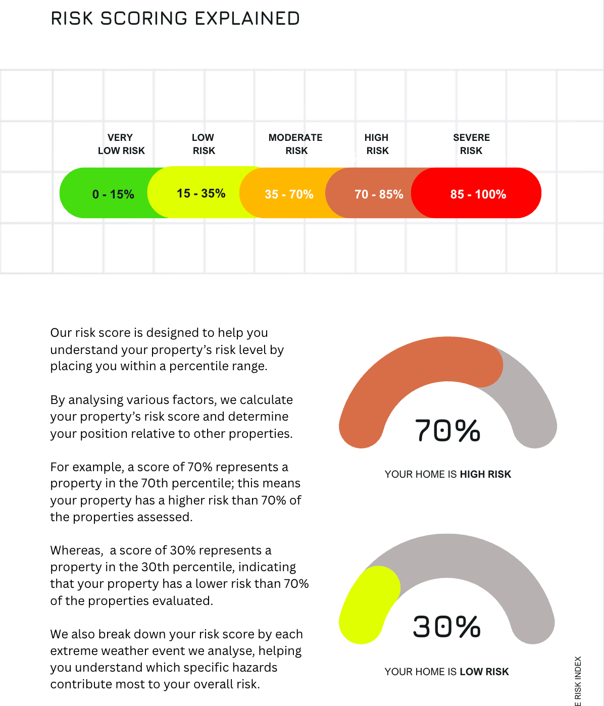
Alongside your overall risk score, we provide a detailed breakdown showing how much risk each of these extreme weather events contributes to your property’s total risk profile. This gives you clarity on which hazards are most significant for your location.
Who Needs An Extreme Weather Risk Report?
Homeowners
Understand your extreme weather risk and determine whether you should enhance your protection to safeguard your property and finances.
Prospective Buyers
Assess extreme weather risks before purchasing to avoid high-risk properties that could lead to costly insurance and financial burdens.
Insurers
Evaluate risk levels accurately to set fair premiums and determine coverage eligibility based on property-specific extreme weather hazards.
FAQs
Where does the data for the report come from?
The report incorporates an extensive array of data to evaluate a multitude of extreme weather hazards. This sophisticated model adjusts the datasets it employs for each state, reflecting the unique reporting methods utilised by state governments, fire departments, and related agencies.
By accommodating these variations, the index ensures that its analysis is as accurate and relevant as possible to the specific conditions and reporting standards present in each region. This tailored approach allows for a more precise assessment of extreme weather risks, enhancing the model's overall effectiveness in predicting fire risk.
The report uses data from a range of trusted sources, including national and state governments, fire services, weather & climate agencies, satellite companies, and our own private database.
How Is the risk score generated?
The algorithm utilised for the report performs an analysis of all available hazard data, evaluating various factors that contribute to extreme weather risk. It considers an array of data points, including historical incidents, proximity to fire and flood-prone areas and vegetation, local weather conditions, climate projections, and the presence of fire and flood mitigation measures. By integrating this diverse set of information, the algorithm generates a risk score for each individual property. This risk score is intended to provide a nuanced assessment of the potential extreme weather hazards associated with each property.
Why is the report only available in VIC and NSW?
Our risk modelling is currently focused on Victoria and New South Wales, where we have the most robust and reliable data to produce accurate property-level insights.
We’re actively working to expand coverage to other states. If you'd like to be notified when reports become available in your area, please complete our contact form and we’ll keep you updated.
What climate models are used?
The report predicts future climate conditions based on an ensemble of climate models. Using an ensemble of climate models provides a more robust and reliable understanding of future climate scenarios by capturing a range of possible outcomes and reducing the uncertainty inherent in any single model. This approach allows the model to identify common trends and patterns, improving the overall confidence in climate projections.
We use the following climate models:
CSIRO-BOM-ACCESS1-0 model 1
The CSIRO-BOM-ACCESS1-0 model represents the 'Maximum Consensus Climate Future'. ACCESS1-0 is a general circulation climate model developed collaboratively by the Commonwealth Scientific and Industrial Research Organisation (CSIRO) and the Bureau of Meteorology (BOM) in Australia.
NorESM1-M model 2
The NorESM1-M model, also known as the Norwegian Earth System Model version 1-Medium resolution, represents the 'Comparatively Coolest and Wettest (least hot and dry) Climate Future'. It represents the (typically much smaller) group of models that show less warming and more rainfall.
HadGEM2-CC model 3
The HadGEM2-CC model represents the 'Comparatively Hottest and Driest (least cool and wet) Climate Future'. It represents the (typically smaller) group of models with a hotter and drier future compared to the other models. HadGEM2-CC model was developed by the UK Met Office Hadley Centre.
These models have been rigorously reviewed by leading climate scientists and approved for use for Australian government and research agencies.
It’s important to note that all climate models, despite their sophisticated and comprehensive nature, have inherent limitations due to the complexity of the Earth's climate system and the uncertainties in data and parameterisations.
How will I receive my report?
You will receive an email with your report attached as a PDF within 24 hours of purchasing.
Why do I need a report if I already know my property is in a BPA?
Knowing your property is in a Bushfire Prone Area is just the first step; it doesn’t tell you how high the risk actually is.
Bushfire risk can vary dramatically between properties within Bushfire Prone Areas. While over 5.6 million Australian homes, including 1.9 million in NSW and over 760,000 in Victoria, are at risk from bushfires, not all properties face the same level of threat.
With climate change increasing the frequency and intensity of fire events, it’s more important than ever to get a detailed, property-specific risk assessment. Our Fire Risk data goes beyond general zoning, providing tailored insights into both current and future fire risk so you can make confident, informed decisions about your property.
We believe in the power of data
At Climate Risk Index, we empower property owners and businesses with the insights they need to understand climate-related risks such as fire and flooding.
We've gathered extensive data, applied advanced climate risk modeling, and distilled the results into clear, actionable insights. Our reports provide a risk score for your property, along with a detailed breakdown of the specific risk factors identified.